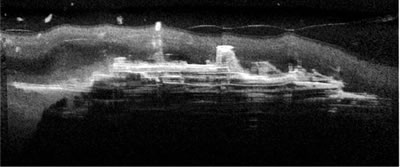
Sonar image of the Mikhail Lermontov resting on the seafloor. (NIWA)
A scientist from New Zealand's National Instute of Water & Atmospheric Research (NIWA) has used sophisticated sonar technology to reveal a ghost-like image of the Mikhail Lermontov lying in its watery grave in the Marlborough Sounds.
Twenty years after sinking, the hull of the Mikhail Lermontov is largely intact on the sea floor. Divers rarely see more than a very small part of the 155 m wreck because underwater visibility is usually poor at Port Gore in the Marlborough Sounds, where the ship has rested since 16 February 1986.
NIWA's Regional Manager in Nelson, Dr Ken Grange, used side-scan sonar to see through the murk and produce an eerie ghost-like image of the wreck. The side-scan sonar uses sound waves to produce digital images, in a similar way that ultra-sound scanners are used to show images of foetuses in the womb. It's really a sophisticated echo-sounder, says Dr Grange. But instead of being mounted on a boat and looking straight down to the seafloor, the transducers (which convert the sound waves into electrical signals) are mounted in a small torpedo-shaped body (a 'towfish') that is towed behind a boat, just a few metres off the seafloor. The ultra-sonic sound waves are emitted almost sideways to skim over the seabed. Any object that is raised above the seafloor bounces the sound waves back, where they are picked up by the towfish and processed into a digital signal that is sent to an onboard computer. Just as in light photography, objects reflecting the sound back appear white, whereas shadows are black.
NIWA purchased the side-scan system specifically for shallow water research, where it has proved invaluable for mapping reefs, sand waves, and other marine habitats, says Dr Grange. For instance we have recently produced a habitat map of the new marine reserve off Nelson, showing all reefs, rocks, boulders, gravel and sand areas. Our system operates at a very high sound frequency of 675 kHz, which allows us to rapidly map swaths of seafloor up to 60 m wide and to record objects, such as individual rocks on a muddy seabed, as small as a football. For the Mikhail Lermontov image, however, we had to stay clear of the wreck itself so as not to run the risk of losing the towfish, so we used a swath width of 100 m.
On the resultant image, the funnel and main davits (cranes), the bridge, and various decks are clearly visible. The bow is not so clear because it is partly buried in the mud. The pale patches above the front half of the wreck are schools of fish in mid-water, perhaps tarakihi.